
Image
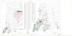
Map showing oil, gas, and gas storage fields in Indiana Public Deposited
- Genre
- Geological maps
- Location
- W0880000 W0860000 N0395000 N0380000
- Coordinates: W0880700 W0844500 N0414500 N0375200
- Related URL
- Abstract
- "Compilation complete to December 1998." "Base map digitized from 1978 U.S. Geological Survey map of Indiana. Scale 1:500,000."
- Call Number
- G4091.H8 1998 .C3
- Caption
- Imprint: Bloomington : Indiana Geological Survey, 1998.
- Filename
- VAC3073-M-00237
- Subject
- Topical Subject: Oil fields
- Geographic Subject: Indiana
- Topical Subject: Gas fields
- Title
- Map showing oil, gas, and gas storage fields in Indiana
- Producer
- Cazee, J. T. (James T.)
- Physical Description
- Scale: 1:550,000
- 1:1:275,000
- Dimensions: 83 x 150 cm
- Item Identifiers
- Title Control Number: a4995550
- Persistent Identifier
- Campus
- IU Bloomington
- Date Created
- 1998
- Publisher
- Indiana. Geological Survey
Relationships
Relationships
- In Collection:
Items
Show Item Images
| Thumbnail | Title | Date Uploaded | Visibility | Actions |
|---|---|---|---|---|
|
VAC3073-M-00237.jp2 | 2023-10-18 | Public |
|