
Image
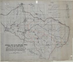
Drainage map of the upper and middle parts of Lost River Basin, Orange, Washington and Lawrence Counties, Indiana Public Deposited
- Genre
- Manuscript maps
- Thematic maps
- Location
- Coordinates: W0864059 W0861220 N0384445 N0383053
- Related URL
- Abstract
- Pen, colored ink and colored pencils on drafting cloth. Includes table of drainage areas.
- Call Number
- G4092.L8C315 1927 .M35
- Caption
- Imprint: [Place of publication not identified] : [publisher not identified], 1927.
- Filename
- VAC3073-M-01239
- Subject
- Geographic Subject: Lawrence County (Ind.)
- Geographic Subject: Lost River Watershed (Ind.)
- Topical Subject: Drainage
- Geographic Subject: Lost River (Ind. : River)
- Geographic Subject: Washington County (Ind.)
- Geographic Subject: Orange County (Ind.)
- Topical Subject: Rivers
- Title
- Drainage map of the upper and middle parts of Lost River Basin, Orange, Washington and Lawrence Counties, Indiana
- Producer
- Malott, Clyde A.
- Physical Description
- Scale: 1:31,680
- Dimensions: 93 x 111 cm
- Persistent Identifier
- Campus
- IU Bloomington
- Date Created
- 1927
- Publisher
- [publisher not identified]
Relationships
Relationships
- In Collection:
Items
Show Item Images
| Thumbnail | Title | Date Uploaded | Visibility | Actions |
|---|---|---|---|---|
|
VAC3073-M-01239.jp2 | 2023-09-28 | Public |
|