
Image
Topographic map of Indiana Public Deposited
- Genre
- Topographic maps
- Location
- Coordinates: W0880500 W0844700 N0414500 N0374600
- Related URL
- Abstract
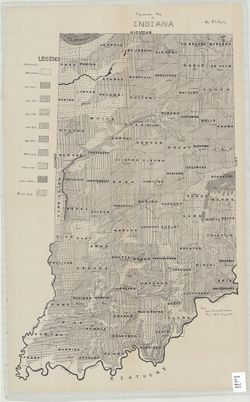
- Relief shown by choropleth methods. "Note: Data--railroad elevations, Plan--after Leverett." Detached from: Topography of Indiana--Map / Edward Barrett. In Thirty-seventh annual report of Dept. of Geology and Natural Resources, Indiana. Indianapolis: Wm. B. Burford, 1913. Page 9.
- Call Number
- G4091.C2 1913 .H4
- Caption
- Imprint: [Indianapolis] : [Indiana Department of Geology and Natural Resources], [1913]
- Filename
- VAC3073-M-01536
- Subject
- Geographic Subject: Indiana
- Topical Subject: IGS Annual Reports
- Title
- Topographic map of Indiana
- Producer
- Hesler, R. S.
- Physical Description
- Dimensions: on sheet 73 x 46 cm
- Scale: Scale not given.
- Item Identifiers
- Alternate ID: 390726IP
- Title Control Number: a18466085
- Persistent Identifier
- Campus
- IU Bloomington
- Date Created
- 1913
- Provenance
- 37th Annual Report (1912) / Indiana. Department of Geology and Natural Resources.
- Publisher
- Indiana. Department of Geology and Natural Resources
Relationships
Relationships
- In Collection:
Items
Show Item Images
| Thumbnail | Title | Date Uploaded | Visibility | Actions |
|---|---|---|---|---|
|
VAC3073-M-01536.jp2 | 2023-09-28 | Public |
|