
Image
Map of the main Trenton rock oil field of Indiana Public Deposited
- Genre
- Geological maps
- Location
- Coordinates: W0854720 W0844820 N0404500 N0400900
- Related URL
- Abstract
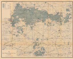
- In 31st Annual report of the Department of Geology and Natural Resources of Indiana, 1906. "January 1, 1907." Shows good, fair, and light oil territory, gas wells, dry holes, abandoned territory, and pumping stations. Detached from: The petroleum industry in Indiana in 1906 / W.S. Blatchley. In Indiana Department of Geology and Natural Resources thirty-first annual report ... 1906. Indianapolis : Wm. B. Burford, 1906. Page 452.
- Call Number
- G4091.H8 1906 .B5
- Caption
- Imprint: Indianapolis, Ind. : Wm. B. Burford, [1907]
- Filename
- VAC3073-M-00778
- Subject
- Topical Subject: Oil fields
- Geographic Subject: Indiana
- Title
- Map of the main Trenton rock oil field of Indiana
- Producer
- Blatchley, W. S. (Willis Stanley), 1859-1940
- Physical Description
- Scale: Approximately 1:126,720. 2 miles = 1 inch
- Dimensions: 53 x 67 cm
- Item Identifiers
- Alternate ID: 390726IP
- Title Control Number: a16077853
- Persistent Identifier
- Campus
- IU Bloomington
- Date Created
- 1907
- Provenance
- 31st Annual Report (1906) / Indiana. Department of Geology and Natural Resources.
- Publisher
- Indiana. Department of Geology and Natural Resources
Relationships
Relationships
- In Collection:
Items
Show Item Images
| Thumbnail | Title | Date Uploaded | Visibility | Actions |
|---|---|---|---|---|
|
VAC3073-00260.jp2 | 2023-09-27 | Public |
|