
Image
Railroad distance & township map of Indiana Public Deposited
- Genre
- Maps
- Location
- Coordinates: W0880700 W0844500 N0414500 N0375200
- Related URL
- Abstract
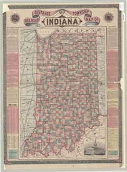
- Shows railroads, counties, townships, cities, towns, and railroad stations. Includes "Description on Indiana", 1870 census figures for counties, cities, and larger towns, "Laws of Indiana", and "Literary Institutions of the state" along both sides of the map. "W. Roberts, sc, NY." "Entered according to Act of congress, by E. C. Bridgman, in the year 1871, in the Office of the Librarian of Congress, at Washington." Hand colored.
- Call Number
- G4090 1871 .B75
- Caption
- Imprint: New York : E.C. Bridgman, c1871.
- Filename
- VAC3073-M-01283
- Subject
- Geographic Subject: Indiana
- Topical Subject: Railroads
- Topical Subject: Administrative and political divisions
- Title
- Railroad distance & township map of Indiana
- Producer
- Bridgman, E. C.
- Physical Description
- Dimensions: 69 x 46 cm
- Scale: Approximately 1:675,000
- Persistent Identifier
- Campus
- IU Bloomington
- Date Created
- 1871
- Publisher
- Bridgman, E. C.
Relationships
Relationships
- In Collection:
Items
Show Item Images
| Thumbnail | Title | Date Uploaded | Visibility | Actions |
|---|---|---|---|---|
|
VAC3073-M-01283.jp2 | 2023-09-28 | Public |
|