
Image
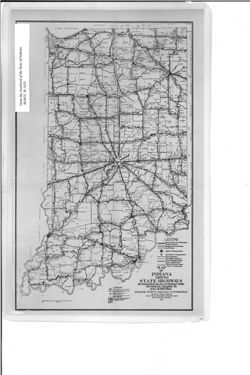
Map of Indiana showing state highways designed in accordance with section 12, chapter 15, Acts of 1919 (Ind.) Public Deposited
- Genre
- Thematic maps
- Road maps
- Location
- Coordinates: W0880700 W0844500 N0414500 N0375200
- Related URL
- Abstract
- Shows brick, concrete and bituminous surfaced roads, stone and gravel roads, and earth roads, as well as hard surfaced roads and stone and gravel roads under construction. Also shows State Highway Commission district headquarters and sub-district headquarters and district and sub-district boundaries. Detached from: Annual report of the State Highway Commission for the fiscal year ending September 30, 1923 / Indiana. State Highway Commission. In Yearbook of the State of Indiana for the year 1923. Indianapolis : Wm. B. Burford, 1924.
- Call Number
- G4091.P2 1923 .I5
- Caption
- Imprint: [Indianapolis] : [Wm. B. Burford], [1924]
- Filename
- VAC3073-M-01037
- Subject
- Topical Subject: Roads
- Geographic Subject: Indiana
- Topical Subject: Administrative and political divisions
- Topical Subject: Road materials
- Title
- Map of Indiana showing state highways designed in accordance with section 12, chapter 15, Acts of 1919 (Ind.)
- Producer
- Indiana. State Highway Commission (1919-1953)
- Physical Description
- Dimensions: 36 x 22 cm
- Scale: Approximately 1:1,330,560
- Item Identifiers
- Alternate ID: 397754IP
- Title Control Number: a15733507
- Persistent Identifier
- Holding Location
- Bloomington - Herman B Wells Library
1320 E 10th St.
Bloomington, IN 47405
Contact at libref@iu.edu, (812) 855-0100
- Bloomington - Herman B Wells Library
- Campus
- IU Bloomington
- Date Created
- 1923
- Provenance
- Year book of the state of Indiana (1923)
- Publisher
- Indiana. Legislative Reference Bureau
Relationships
Relationships
- In Collection:
Items
Show Item Images
| Thumbnail | Title | Date Uploaded | Visibility | Actions |
|---|---|---|---|---|
|
VAC3073-00298.jp2 | 2023-09-27 | Public |
|