
Image
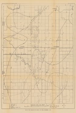
Map of the Oakland City, Indiana, oil field, December 1, 1910 Public Deposited
- Genre
- Geological maps
- Location
- Coordinates: W0872300 W0871300 N0382200 N0381200
- Related URL
- Abstract
- Shows oil and gas wells. "Structure contours above sea level showing coal V or its position before erosion."--Legend. Detached from: The Oakland City, Indiana, oil field in 1910 / Ralph F. Blatchley. In Indiana Dept. of Geology and Natural Resources thirty-fifth annual report, 1910. Indianapolis: Wm. B. Burford, 1911. Page 79.
- Call Number
- G4094.O2H8 1910 .M3
- Caption
- Imprint: [Indianapolis] : [Indiana Dept. of Geology and Natural Resources], [1911]
- Filename
- VAC3073-M-00671
- Subject
- Geographic Subject: Pike County (Ind.)
- Geographic Subject: Oakland City (Ind.)
- Geographic Subject: Gibson County (Ind.)
- Topical Subject: Gas wells
- Topical Subject: IGS Annual Reports
- Topical Subject: Oil wells
- Title
- Map of the Oakland City, Indiana, oil field, December 1, 1910
- Physical Description
- Scale: Approximately 1:21,500
- Dimensions: 57 x 40 cm
- Item Identifiers
- Title Control Number: a18307759
- Alternate ID: 390726IP
- Persistent Identifier
- Campus
- IU Bloomington
- Date Created
- 1911
- Provenance
- 35th Annual Report (1910) / Indiana. Department of Geology and Natural Resources.
- Publisher
- Indiana. Department of Geology and Natural Resources
Relationships
Relationships
- In Collection:
Items
Show Item Images
| Thumbnail | Title | Date Uploaded | Visibility | Actions |
|---|---|---|---|---|
|
VAC3073-00186.jp2 | 2023-09-25 | Public |
|