
Image
Indiana-Ohio, Winchester quadrangle [1918 printing] Public Deposited
- Genre
- Topographic maps
- Quadrangle maps
- 15 minute topographic maps
- Location
- Coordinates: W0850000 W0844500 N0401500 N0400000
- Related URL
- Abstract
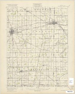
- W.H. Herron, acting chief geogrpher , Glenn S. Smith, topographic engineer in charge , topography by R.L. Harrison and W.L. Miller , control by J.R. Ellis, J.H. Wilson, E.C. Bibbee, L.B. Glasgow, and H.W. Peabody , engraved 1918 by U.S.G.S. Filing title: Winchester, Ind.-O. Edition of 1918. Polyconic projection. Relief shown by contours and spot heights. Contour interval 20 feet. Includes map of areas surveyed by Miller and Harrison. Shows portion of Randolph County, Indiana, and small portions of Darke County, Ohio, and Wayne County, Indiana. Some copies show forest areas colored green. "Surveyed in cooperation with the State of Ohio." Reprinted 1958.
- Call Number
- G4090 s62 .G4 Winchester
- Caption
- Imprint: [Washington, D.C.] : U.S. Geological Survey, [1918]
- Filename
- VAC3073-M-01414
- Subject
- Geographic Subject: Wayne County (Ind.)
- Geographic Subject: Randolph County (Ind.)
- Geographic Subject: Darke County (Ohio)
- Title
- Indiana-Ohio, Winchester quadrangle [1918 printing]
- Producer
- Geological Survey (U.S.)
- Harrison, R. L. (Topographer)
- Herron, W. H. (William Harrison), 1865-
- Miller, W. L. (Topographer)
- Ellis, J. R. (Topographer)
- Smith, Glenn S. (Glenn Shepard)
- Ohio. Division of Geological Survey
- Physical Description
- Dimensions: 45 x 42 cm or smaller
- Scale: 1:62,500
- Item Identifiers
- Title Control Number: a18416004
- Persistent Identifier
- Holding Location
- Bloomington - Herman B Wells Library
1320 E 10th St.
Bloomington, IN 47405
Contact at libref@iu.edu, (812) 855-0100
- Bloomington - Herman B Wells Library
- Campus
- IU Bloomington
- Provenance
- Part of Geological Survey (U.S.). Indiana 1:62,500.
- Publisher
- Geological Survey (U.S.)
Relationships
Relationships
- In Collection:
Items
Show Item Images
| Thumbnail | Title | Date Uploaded | Visibility | Actions |
|---|---|---|---|---|
|
VAC3073-M-01414.jp2 | 2023-09-28 | Public |
|