
Image
Pituophis Catenife[r] Blainville Public Deposited
- Location
- United States
- Mexico
- Abstract
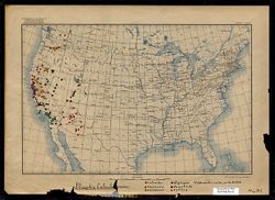
- One of a series of maps created or annotated by Alfred C. Kinsey. Most contain gall wasp data. Several only contain data on other types of flora and fauna. On this map, data points appear in Arizona, California, Idaho, Nevada, Oregon, Utah, and Washington. Data points also extend into the Mexican state of Baja California (listed on base map in English as "Lower California") and the Arizona/Mexico border. Species are listed in Latin (binomial nomenclature) and color coded (see Caption field). This map is torn such that the final "r" in the title is missing.
- Caption
- catenifer, heermanni, annectens, stejnegeri, deserticola, rutilus, ?? determination uncertain, possibly deserticola.
- Country
- United States
- Filename
- VAE1595-000007
- Subject
- Snakes
- Entomologists
- Title
- Pituophis Catenife[r] Blainville
- Producer
- Kinsey, Alfred C. (Alfred Charles), 1894-1956
- Physical Description
- Scale: 1:11,875,000
- Print Size: 7.5 x 11.5
- Base map type 1 (USGS. Edition of May 1906, reprinted 1922.) Map scale indicated in both graphic representation and representative fraction.
- Language
- Latin
- English
- Item Identifiers
- Map D1
- Persistent Identifier
- Campus
- IU Bloomington
- Date Created
- 1917-1937
Relationships
Relationships
- In Collection:
Items
Show Item Images
| Thumbnail | Title | Date Uploaded | Visibility | Actions |
|---|---|---|---|---|
|
VAE1595-000007.jp2 | 2024-04-01 | Public |
|