
Image
Indiana Noblesville quadrangle [Advance sheet] Public Deposited
- Genre
- Topographic maps
- 15 minute topographic maps
- Quadrangle maps
- Location
- Coordinates: W0861500 W0860000 N0401500 N0400000
- Related URL
- Abstract
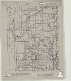
- Surveyed by H.W. Klausmann. Relief shown by contours. Contour interval 10 feet. Shows portion of Hamilton County as well as small portions Tipton and Boone counties in Indiana. "Contour map of the White River Basin, Indiana, from the scource [sic] of river to Indianapolis surveyed by H.W. Klausmann, City Civil Engineer of Indianapolis, approved January 5th, 1914." "Advance sheet. Subject to correction."
- Call Number
- G4090 s62 .G4 Noblesville 1914 ADV
- Caption
- Imprint: [Washington, D.C.?] : [U.S. Geological Survey?], [1914?]
- Filename
- VAC3073-M-01447
- Subject
- Geographic Subject: Tipton County (Ind.)
- Geographic Subject: Whitewater River Watershed (Ind. and Ohio)
- Geographic Subject: Boone County (Ind.)
- Geographic Subject: Hamilton County (Ind.)
- Topical Subject: Watersheds
- Title
- Indiana Noblesville quadrangle [Advance sheet]
- Producer
- Klausmann, H. W. (Henry "Harry" W.), 1868-1918
- Physical Description
- Dimensions: 45 x 42 cm or smaller
- Scale: 1:48,000
- Item Identifiers
- Title Control Number: a18413827
- Persistent Identifier
- Holding Location
- Bloomington - Herman B Wells Library
1320 E 10th St.
Bloomington, IN 47405
Contact at libref@iu.edu, (812) 855-0100
- Bloomington - Herman B Wells Library
- Campus
- IU Bloomington
- Date Created
- 1914
- Provenance
- Part of Geological Survey (U.S.). Indiana 1:62,500.
- Publisher
- Geological Survey (U.S.)
Relationships
Relationships
- In Collection:
Items
Show Item Images
| Thumbnail | Title | Date Uploaded | Visibility | Actions |
|---|---|---|---|---|
|
VAC3073-M-01447.jp2 | 2023-09-28 | Public |
|