
Image
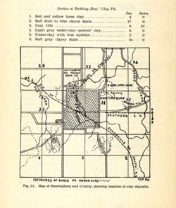
Map of Huntingburg and vicinity, showing the location of clay deposits Public Deposited
- Genre
- Geological maps
- Location
- Coordinates: W0865919 W0865616 N0381927 N0381621
- Related URL
- Abstract
- Shows locations of clay deposits and local brick and tile companies. Also includes listings of measurements for the Bockting Bros.' clay pit. "Fig. 11. "RSB DEL." Detached from: The clays and clay industries of Indiana / W. S. Blatchley. In Indiana Department of Geology and Natural Resources twenty-ninth annual report ... 1904. Indianapolis : Wm. B. Burford, 1905. Page 284.
- Call Number
- G4094.H8H5 1904 .M37
- Caption
- Imprint: [Indianapolis] : [Wm. B. Burford], [1905]
- Imprint: [Indianapolis] : [Indiana Department of Geology and Natural Resources], [1905]
- Filename
- VAC3073-M-01587
- Subject
- Geographic Subject: Huntingburg Region (Ind.)
- Topical Subject: Clay
- Topical Subject: IGS Annual Reports
- Geographic Subject: Dubois County (Ind.)
- Topical Subject: Clay industries
- Title
- Map of Huntingburg and vicinity, showing the location of clay deposits
- Producer
- Blatchley, Raymond S. (Raymond Sillliman)
- Physical Description
- Scale: Approximately 1:46,650
- Dimensions: on sheet 17 x 14 cm
- Item Identifiers
- Alternate ID: 390726IP
- Title Control Number: a18282191
- Persistent Identifier
- Campus
- IU Bloomington
- Date Created
- 1905
- Provenance
- 29th Annual Report (1904) / Indiana. Department of Geology and Natural Resources.
- Publisher
- Indiana. Department of Geology and Natural Resources
Relationships
Relationships
- In Collection:
Items
Show Item Images
| Thumbnail | Title | Date Uploaded | Visibility | Actions |
|---|---|---|---|---|
|
VAC3073-M-01587.jp2 | 2023-09-28 | Public |
|