
Image
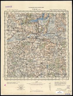
N-34-133 Конин Public Deposited
- Original Publication Date
1903
- Genre
- Military Maps
- Topographic Maps
- Location
- Coordinates: 52, 18, 52.333, 18.5
- Related URL
- Abstract
- Modern area represented: Konin, Greater Poland Voivodeship, Poland
- Call Number
- G7000 s100 .S7 sheet N-34-133
- City
- Конин (Konin)
- Copyright Owner
- No Copyright - United States
- Filename
- VAC9619-003994
- Subject
- Topical Subject: Soviet Union
- Topical Subject: Maps
- Geographic Subject: Konin
- State/Region
- Область государственных интересов Германии (Region of German state interests)
- Title
- N-34-133 Конин
- Physical Description
- Scale: 1:100,000
- Language
- Russian
- Persistent Identifier
- Campus
- IU Bloomington
- Date Created
- 1940
- Provenance
- DMA Topographic Center, Army Map Service Library, Auswärtiges Amt. Geographischer Dienst
- Publisher
- Генеральный штаб Красной Армии
Relationships
Relationships
- In Collection:
Items
Show Item Images
| Thumbnail | Title | Date Uploaded | Visibility | Actions |
|---|---|---|---|---|
|
VAC9619-003994.jp2 | 2024-02-12 | Public |
|
|
VAC9619-U-004128.jp2 | 2024-02-12 | Public |
|