
Image
Geological map of the coal region of Indiana. Sheet F, Warrick, Spencer, and Perry counties Public Deposited
- Genre
- Geological cross-sections
- Geological maps
- Location
- Coordinates: W0872823 W0862942 N0381446 N0374639
- Related URL
- Abstract
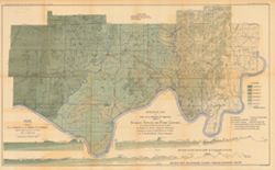
- Relief shown by profile. Shows two geological cross-sections. "Based upon Congressional land surveys, field work of Ind. Geol. Survey, county atlases." Geology by G.H. Ashley, J.A. Price and E.M. Kindle, Spencer County drawn by J.A. Price. Detached from: The coal deposits of Indiana / George Hall Ashley. In Indiana Department of Geology and Natural Resources twenty-third annual report, 1898. Indianapolis : Wm. B. Burford, 1899. Page 1264.
- Call Number
- G4093.W4H9 1898 .A8x
- Caption
- Imprint: Indianapolis : Burford, [1899]
- Imprint: [Indianapolis, Ind.] : Dept. of Geology and Natural Resources of Indiana, [1899]
- Filename
- VAC3073-M-00931
- Subject
- Geographic Subject: Warrick County (Ind.)
- Geographic Subject: Spencer County (Ind.)
- Topical Subject: Geology
- Topical Subject: IGS Annual Reports
- Geographic Subject: Perry County (Ind.)
- Topical Subject: Coal
- Geographic Subject: Indiana
- Title
- Geological map of the coal region of Indiana. Sheet F, Warrick, Spencer, and Perry counties
- Producer
- Ashley, Geo. H. (George Hall), 1866-1951
- Price, J. A.
- Kindle, E. M. (Edward Martin), 1869-1940
- Physical Description
- Scale: Approximately 1:126,720. 2 miles = 1 inch. Vertical scale approximately 1:4,800. 400 feet = 1 inch
- Dimensions: 49 x 77 cm
- Item Identifiers
- Alternate ID: 390726IP
- Title Control Number: a16848969
- Persistent Identifier
- Campus
- IU Bloomington
- Date Created
- 1899
- Provenance
- 23rd Annual Report (1898) / Indiana. Department of Geology and Natural Resources.
- Publisher
- Indiana. Department of Geology and Natural Resources
Relationships
Relationships
- In Collection:
Items
Show Item Images
| Thumbnail | Title | Date Uploaded | Visibility | Actions |
|---|---|---|---|---|
|
VAC3073-00068.jp2 | 2023-09-27 | Public |
|