
Image
L-35-35 Григориополь 公开 Deposited
- Original Publication Date
1874
- Genre
- Military Maps
- Topographic Maps
- Location
- Coordinates: 47, 29, 47.3333, 29.5
- Related URL
- Abstract
- Modern area represented: Hryhoriopol, Stînga Nistrului, Moldova
- Call Number
- G7000 s100 .S7 sheet L-35-35
- Caption
- Не подлежит оглашению
- City
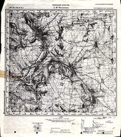
- Григориополь (Hryhoriopol)
- Copyright Owner
- No Copyright - United States
- Filename
- VAC9619-001531
- Subject
- Topical Subject: Soviet Union
- Geographic Subject: Hryhoriopol
- Topical Subject: Maps
- State/Region
- Бессарабия (Bessarabia)
- Молдавская АССР (Moldavian Autonomous Soviet Socialist Republic)
- Украинская ССР (Ukrainian Soviet Socialist Republic)
- Title
- L-35-35 Григориополь
- Physical Description
- Scale: 1:100,000
- Language
- Russian
- Persistent Identifier
- Campus
- IU Bloomington
- Date Created
- 1916
- Provenance
- DMA Topographic Center, Army Map Service Library, Library of Congress Geography & Map Division
- Publisher
- Генеральный штаб РККА
Relationships
关联
- 属于 Collection:
Items
Show Item Images
| 缩略图 | 标题 | 上传日期 | 公开度 | 行动 |
|---|---|---|---|---|
|
VAC9619-001531.jp2 | 2024-03-02 | 公开 |
|
|
VAC9619-U-000202.jp2 | 2024-03-02 | 公开 |
|