
Image
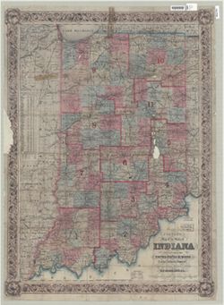
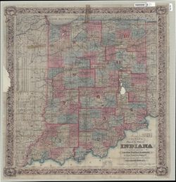
Colton's map of the state of Indiana : compiled from the United States surveys & other authentic sources, exhibiting sections, fractional sections, railroads, canals &c. Public Deposited
- Genre
- Thematic maps
- Location
- Coordinates: W0880700 W0844500 N0414500 N0375200
- Related URL
- Abstract
- "Entered according to act of Congress in the year 1852 ..." Also shows congressional districts. Includes inset tables "Statistics of population & c." and "Progress of population." Also shows congressional districts. Includes inset tables "Statistics of population &c." and "Progress of population."
- Call Number
- G4090 1854 .C6
- Caption
- Imprint: New York : J.H. Colton, 1854
- Filename
- VAC3073-M-01277
- Subject
- Topical Subject: Election districts
- Topical Subject: Administrative and political divisions
- Geographic Subject: Indiana
- Topical Subject: Railroads
- Topical Subject: Roads
- Topical Subject: Canals
- Title
- Colton's map of the state of Indiana : compiled from the United States surveys & other authentic sources, exhibiting sections, fractional sections, railroads, canals &c.
- Producer
- Colton, J. H. (Joseph Hutchins), 1800-1893
- Physical Description
- Dimensions: 91 x 63 cm
- Scale: Scale not given.
- Persistent Identifier
- Campus
- IU Bloomington
- Date Created
- 1854
- Publisher
- J.H. Colton & Co.
Relationships
Relationships
- In Collection:
Items
Show Item Images
| Thumbnail | Title | Date Uploaded | Visibility | Actions |
|---|---|---|---|---|
|
VAC3073-M-01277.jp2 | 2023-09-28 | Public |
|
|
VAC3073-00935.jp2 | 2023-09-28 | Public |
|