
Image
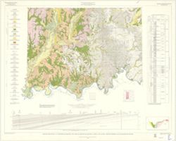
Geologic map of the 1° x 2° Vincennes Quadrangle and parts of adjoining quadrangles, Indiana and Illinois, showing bedrock and unconsolidated deposits Public Deposited
- Genre
- Quadrangle maps
- Geological maps
- Geological cross-sections
- Location
- Coordinates: W0880000 W0860000 N0390000 N0380000
- Related URL
- Abstract
- By Henry H. Gray, William J. Wayne, and Charles E. Wier , Indiana Geological Survey, in cooperation with Illinois State Geological Survey. Transverse Mercator projection. Vincennes sheet shows both bedrock and unconsolidated deposits, sheet A shows only bedrock, and sheet B shows only unconsolidated deposits. Each sheet includes in borders columnar section showing bedrock units, cross section showing configuration of land surface and bedrock units, schematic section showing relationships of unconsolidated deposits, index map showing published quadrangles, sectionized township diagram, and diagrams showing areas of primary responsibility for glacial geology and bedrock geology.
- Call Number
- G4091.C5 s250 .I5 Vincennes 1970
- Filename
- VAC3073-M-01257
- Subject
- Geographic Subject: Illinois
- Topical Subject: Geology
- Topical Subject: Geology, Stratigraphic
- Geographic Subject: Indiana
- Title
- Geologic map of the 1° x 2° Vincennes Quadrangle and parts of adjoining quadrangles, Indiana and Illinois, showing bedrock and unconsolidated deposits
- Producer
- Gray, Henry Hamilton, 1922-
- Wier, Charles E. (Charles Eugene), 1921-
- Indiana. Geological Survey
- Wayne, William J. (William John), 1922-
- Illinois State Geological Survey
- Physical Description
- Dimensions: 76 x 102 cm
- Scale: 1:250,000
- Item Identifiers
- Title Control Number: a18455600
- Persistent Identifier
- Campus
- IU Bloomington
- Date Created
- 1970
- Provenance
- Indiana. Geological Survey. Regional geologic map , no. 3.
- Publisher
- Indiana. Geological Survey
Relationships
Relationships
- In Collection:
Items
Show Item Images
| Thumbnail | Title | Date Uploaded | Visibility | Actions |
|---|---|---|---|---|
|
VAC3073-M-01257.jp2 | 2023-09-28 | Public |
|