
Image
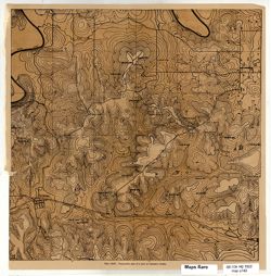
Topographic map of a part of Lawrence County, [Indiana] Public Deposited
- Genre
- Topographic maps
- Location
- Coordinates: W0864102 W0863335 N0384723 N0384112
- Related URL
- Abstract
- At head of title: Plate LXIX. Relief shown by contours. Detached from: Handbook of Indiana geology, part 2 / by W. N. Logan, E. R. Cumings, C. A. Malott, S. S. Visher, W. M. Tucker, J. R. Reeves. Indianapolis : Wm. B. Burford, contractor for state printing and binding, 1922. Page 742.
- Call Number
- G4093.L5C2 1922 .T6
- Caption
- Imprint: [Indianapolis] : [Wm. B. Burford], [1922]
- Imprint: [Indianapolis] : [Department of Conservation, Division of Geology], [1922]
- Filename
- VAC3073-M-01131
- Subject
- Geographic Subject: Lawrence County (Ind.)
- Title
- Topographic map of a part of Lawrence County, [Indiana]
- Physical Description
- Dimensions: 31 x 31 cm
- Scale: Scale not given.
- Item Identifiers
- Title Control Number: a18392653
- Alternate ID: 243508IP
- Persistent Identifier
- Campus
- IU Bloomington
- Date Created
- 1922
- Provenance
- Handbook of Indiana geology, part 2 (1922) / by W. N. Logan, E. R. Cumings, C. A. Malott, S. S. Visher, W. M. Tucker, J. R. Reeves.
- Publisher
- Indiana. Division of Geology
Relationships
Relationships
- In Collection:
Items
Show Item Images
| Thumbnail | Title | Date Uploaded | Visibility | Actions |
|---|---|---|---|---|
|
VAC3073-M-01131.jp2 | 2023-09-27 | Public |
|