
Image
Maps for General Atlas Public Deposited
- Series
- GLOVE - Local and Regional Maps
- Abstract
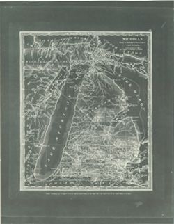
- Entered according to act of Congress in the year 1831 by David H. Burr in the Clerk's Office of the District Court for the Southern District of New-York.
- Call Number
- GLV157
- Copyright Holder
- Public Domain
- Country
- United States
- Persistent URL
- Source Identifier
- VAD5944-000044
- Subject
- American Indians
- Indians of North America
- United States--Maps
- Holding Location
- Bloomington - Indiana University Museum of Archaeology and Anthropology
416 North Indiana Avenue
Bloomington, IN 47408
Contact at iumaa@iu.edu, 812-855-6873
- Bloomington - Indiana University Museum of Archaeology and Anthropology
- Campus
- IU Bloomington
- Source Metadata Identifier
- Title
- Maps for General Atlas
- Creator
- Burr, David H.
- Date Created
- 1831
- Physical Description
- Scale of American Miles: 50 miles to 3 centimeters.
Relationships
Relationships
Items
Show Item Images
| Thumbnail | Title | Date Uploaded | Visibility | Actions |
|---|---|---|---|---|
|
VAD5944-000044.tif | 2023-04-12 | Public |
|