
Image
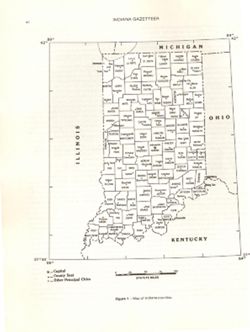
Map of Indiana counties Public Deposited
- Genre
- Maps
- Location
- Coordinates: W0890000 W0840000 N0420000 N0373000
- Related URL
- Abstract
- At head of caption title: "Figure 1." Appears as Figure 1 in Indiana Gazetteer produced by the U.S.G.S. Professional Paper 1200-I. "The National Gazetteer of the United States of America--Indiana 1988. Prepared by the U.S. Geological Survey in cooperation with the U.S. Board on Geographic names. Appears in The National gazetteer of the United States of America--Indiana, 1988 / prepared by the U.S. Geological Survey in cooperation with the U.S. Board on Geographic Names. [Renton, Va.] : The Survey , Denver, Co. : For sale by the Books and Open-File Reports Section, U.S. Geological Survey, 1988. Page xii.
- Call Number
- QE75 .A4 No. 1200-IN
- Caption
- Imprint: [Reston, Va.] : [The Survey], [1988]
- Filename
- VAC3073-M-00025
- Subject
- Topical Subject: Counties
- Geographic Subject: Indiana
- Topical Subject: Administrative and political divisions
- Title
- Map of Indiana counties
- Producer
- Geological Survey (U.S.)
- Physical Description
- Dimensions: 29 cm or smaller
- Scale: Approximately 1:3,200,000
- Item Identifiers
- Title Control Number: a18428209
- Alternate ID: 358171IP
- Persistent Identifier
- Campus
- IU Bloomington
- Date Created
- 1988
- Provenance
- The National gazetteer of the United States of America--Indiana, 1988 / U.S. Geological Survey.
- Publisher
- Geological Survey (U.S.)
Relationships
Relationships
- In Collection:
Items
Show Item Images
| Thumbnail | Title | Date Uploaded | Visibility | Actions |
|---|---|---|---|---|
|
VAC3073-M-00025.jp2 | 2023-09-21 | Public |
|