
Image
Map of counties in northern Indiana showing distributiion of road-materials Public Deposited
- Genre
- Thematic maps
- Geological maps
- Location
- Coordinates: W0864500 W0844800 N0414500 N0402100
- Related URL
- Abstract
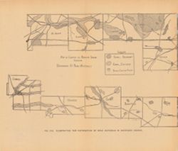
- Alternate title: Illustrating the distribution of road materials in northern Indiana. At head of alternate title: Fig. 23A. Shows areas of abundant and sufficient gravel and stone-crushing plants. Detached from: The roads and road materials of the northern third of Indiana / L.C. Ward. In Indiana Dept. of Geology and Natural Resources thirtieth annual report, 1905. Indianapolis: Wm. B. Burford, 1906. Page 160.
- Call Number
- G4091.H5 1905 .M37
- Caption
- Imprint: [Indianapolis] : [Indiana Dept. of Geology and Natural Resources], [1906]
- Filename
- VAC3073-M-00360
- Subject
- Topical Subject: Sand and gravel plants
- Topical Subject: IGS Annual Reports
- Topical Subject: Road materials
- Geographic Subject: Indiana
- Title
- Map of counties in northern Indiana showing distributiion of road-materials
- Physical Description
- Scale: Scale not given.
- Dimensions: on sheet 23 x 27 cm
- Item Identifiers
- Title Control Number: a18299087
- Alternate ID: 390726IP
- Persistent Identifier
- Campus
- IU Bloomington
- Date Created
- 1906
- Provenance
- 30th Annual Report (1905) / Indiana. Department of Geology and Natural Resources.
- Publisher
- Indiana. Department of Geology and Natural Resources
Relationships
Relationships
- In Collection:
Items
Show Item Images
| Thumbnail | Title | Date Uploaded | Visibility | Actions |
|---|---|---|---|---|
|
VAC3073-00084.jp2 | 2023-09-25 | Public |
|