
Image
Bloomington, Monroe Co., Indiana Public Deposited
- Genre
- Census data
- Thematic maps
- Location
- Coordinates: W0864108 W0861902 N0392120 N0385926
- Related URL
- Abstract
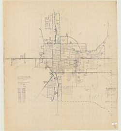
- Blue line print. Shows 1970 census enumeration districts and census tracts for Bloomington, Ind. "Traced from map no. 68-A-8776." "70-02132, Bloomington, Ind."
- Call Number
- G4094.B5 E25 1970 .U5
- Caption
- Imprint: [Jeffersonville, Ind.] : Bureau of the Census, [1974?]
- Filename
- VAC3073-M-00892
- Subject
- Geographic Subject: Bloomington (Ind.)
- Geographic Subject: Monroe County (Ind.)
- Topical Subject: Census districts
- Title
- Bloomington, Monroe Co., Indiana
- Producer
- United States. Bureau of the Census
- Physical Description
- Dimensions: 120 x 107 cm
- Scale: 1:1,500
- Item Identifiers
- Title Control Number: a5300402
- Persistent Identifier
- Campus
- IU Bloomington
- Date Created
- 1974
- Publisher
- United States. Bureau of the Census
Relationships
Relationships
- In Collection:
Items
Show Item Images
| Thumbnail | Title | Date Uploaded | Visibility | Actions |
|---|---|---|---|---|
|
VAC3073-M-00892.jp2 | 2023-10-17 | Public |
|