
Image
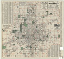
Dreher's Mile square index map of the City of Indianapolis Public Deposited
- Genre
- Road maps
- Location
- Coordinates: W0861941 W0855614 N0395538 N0393755
- Related URL
- Abstract
- "The crossroads of America." Includes one mile distance circles centered on Monument Circle, street index and advertisements. Includes "Dreher's county, township and 'all the roads' map of Central Indiana : showing all dedicated highways--improved and unimproved--state roads, main inter-county roads, townships, cities, towns and villages of the environs of Indianapolis," indexes and advertisements on verso. Includes indexes.
- Call Number
- G4094.I4 1931 .S95
- Caption
- Imprint: [United States] : D. Frank Dreher, [1931]
- Filename
- VAC3073-M-00147
- Subject
- Topical Subject: Roads
- Geographic Subject: Indianapolis (Ind.)
- Geographic Subject: Indianapolis Region (Ind.)
- Title
- Dreher's Mile square index map of the City of Indianapolis
- Producer
- Swinehart, C. V.
- Physical Description
- Scale: 1:31,000
- Dimensions: 75 x 79 cm
- Item Identifiers
- Title Control Number: a7201971
- Persistent Identifier
- Campus
- IU Bloomington
- Date Created
- 1931
- Publisher
- Dreher, D. Frank
Relationships
Relationships
- In Collection:
Items
Show Item Images
| Thumbnail | Title | Date Uploaded | Visibility | Actions |
|---|---|---|---|---|
|
VAC3073-M-00147.jp2 | 2023-09-22 | Public |
|

|
VAC3073-00947.jp2 | 2023-09-22 | Public |
|