
Image
Indiana-Illinois Princeton quadrangle [1942 reprint with corrections] Public Deposited
- Genre
- Quadrangle maps
- Topographic maps
- 15 minute topographic maps
- Location
- Coordinates: W0874500 W0873000 N0383000 N0381500
- Related URL
- Abstract
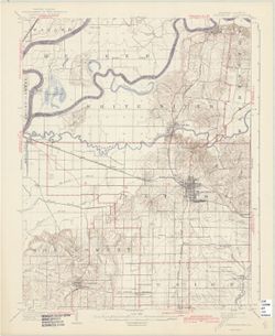
- Jno. H. Renshawe, geographer in charge , control by Geo. T. Hawkins , topography by Chas. W. Goodlove. Filing title: Princeton, Ind.-Ill. Edition of 1903, reprinted 1942 with corrections. Relief shown by contours and spot heights. Contour interval 20 feet. Shows portion of Gibson County, Indiana, and small portions of Knox County, Indiana, and Wabash County, Illinois. "Culture revised in part, 1940." "N3815-W8730/15."
- Call Number
- Part of Geological Survey (U.S.). Indiana 1:62,500.
- Caption
- Imprint: [Washington, D.C.] : U.S. Geological Survey, 1942.
- Filename
- VAC3073-M-01385
- Subject
- Geographic Subject: Gibson County (Ind.)
- Geographic Subject: Knox County (Ind.)
- Title
- Indiana-Illinois Princeton quadrangle [1942 reprint with corrections]
- Producer
- Geological Survey (U.S.)
- Goodlove, C. W.
- Renshawe, John H.
- Hawkins, Geo. T. (George T.)
- Physical Description
- Dimensions: 45 x 42 cm or smaller
- Scale: 1:62,500
- Item Identifiers
- Title Control Number: a18413585
- Persistent Identifier
- Campus
- IU Bloomington
- Date Created
- 1942
- Provenance
- Part of Geological Survey (U.S.). Indiana 1:62,500.
- Publisher
- Geological Survey (U.S.)
Relationships
Relationships
- In Collection:
Items
Show Item Images
| Thumbnail | Title | Date Uploaded | Visibility | Actions |
|---|---|---|---|---|
|
VAC3073-M-01385.jp2 | 2023-09-28 | Public |
|