
Image
Dubois County soil map Public Deposited
- Genre
- Thematic maps
- Location
- Coordinates: W0870420 W0864048 N0383133 N0381222
- Related URL
- Abstract
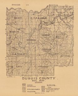
- Shows school houses, public roads, and railroads. Detached from: A soil survey of four counties of southern Indiana / Chas. W. Shannon and L.C. Snider. In Indiana Department of Geology and Natural Resources thirty-third annual report ... 1908. Indianapolis : Wm. B. Burford, 1909. Page 284.
- Call Number
- G4093.D8J3 1908 .I53
- Caption
- Imprint: [Indianapolis] : [Indiana Department of Geology and Natural Resources], [1909]
- Filename
- VAC3073-M-00808
- Subject
- Topical Subject: Soils
- Geographic Subject: Dubois County (Ind.)
- Title
- Dubois County soil map
- Producer
- Indiana. Department of Geology and Natural Resources
- Physical Description
- Scale: Approximately 1:126,720
- Dimensions: 39 x 33 cm
- Item Identifiers
- Title Control Number: a16091036
- Alternate ID: 390726IP
- Persistent Identifier
- Campus
- IU Bloomington
- Date Created
- 1909
- Provenance
- 33rd Annual Report (1908) / Indiana. Department of Geology and Natural Resources.
- Publisher
- Indiana. Department of Geology and Natural Resources
Relationships
Relationships
- In Collection:
Items
Show Item Images
| Thumbnail | Title | Date Uploaded | Visibility | Actions |
|---|---|---|---|---|
|
VAC3073-00089.jp2 | 2023-09-27 | Public |
|