
Image
Maps of Greencastle and Putnam County Indiana Public Deposited
- Genre
- Cadastral maps
- Location
- Coordinates: W0865246 W0864752 N0393930 N0393728
- Related URL
- Abstract
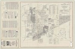
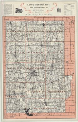
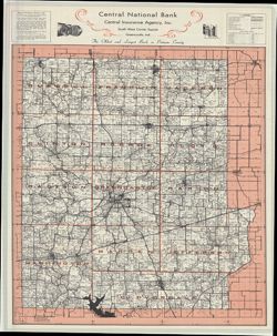
- Map of Greencastle, Ind.: Cadastral map , "Original map prepared by Wm. P. Koehler, 1925 - revised by John Howard R.E..., 1946 - Revised by Granville C. Thompson R.E. ..., 1951,1956."Map of Putnam County, Ind.: Cadastral map showing landowners , "[Land] title changes revised October, 1956."
- Call Number
- G4094.G5G46 1956 .M37
- Caption
- Imprint: Greencastle, Ind. : Central National Bank of Greencastle, Indiana, [1957]
- Filename
- VAC3073-M-00431
- Subject
- Geographic Subject: Putnam County (Ind.)
- Topical Subject: Real property
- Topical Subject: Landowners
- Geographic Subject: Greencastle (Ind.)
- Title
- Maps of Greencastle and Putnam County Indiana
- Physical Description
- Dimensions: 55 x 64 cm and 77 x 54 cm
- Scale: 1:3,600
- Item Identifiers
- Title Control Number: CAP8871BB
- Persistent Identifier
- Campus
- IU Bloomington
- Date Created
- 1956
- Publisher
- Central National Bank (Greencastle, Ind.)
Relationships
Relationships
- In Collection:
Items
Show Item Images
| Thumbnail | Title | Date Uploaded | Visibility | Actions |
|---|---|---|---|---|
|
VAC3073-M-00431.jp2 | 2023-09-25 | Public |
|
|
VAC3073-00474.jp2 | 2023-09-25 | Public |
|
|
VAC3073-00920.jp2 | 2023-09-25 | Public |
|