
Image
Mendenhall's guide and road map to Indiana : showing main touring routes & good roads Public Deposited
- Genre
- Road maps
- Location
- Coordinates: W0880700 W0844500 N0414500 N0375200
- Related URL
- Abstract
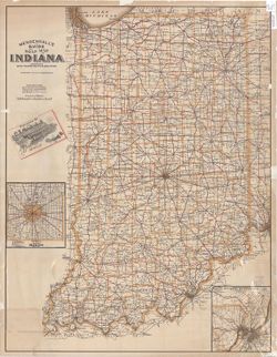
- Insets: Marion County, Ind.--New Albany, Jeffersonville and louisville District. Includes 20 p. text describing 163 different tour routes.
- Call Number
- G4091.P2 1906 .C74
- Caption
- Imprint: Cincinnati : C.S. Mendenhall, [1906]
- Filename
- VAC3073-M-00687
- Subject
- Geographic Subject: Indiana
- Topical Subject: Roads
- Title
- Mendenhall's guide and road map to Indiana : showing main touring routes & good roads
- Producer
- C.S. Mendenhall (Firm)
- Physical Description
- Scale: 1:550,000
- Dimensions: 89 x 68 cm
- Item Identifiers
- Title Control Number: CAG9468BB
- Persistent Identifier
- Campus
- IU Bloomington
- Date Created
- 1906
- Publisher
- C.S. Mendenhall (Firm)
Relationships
Relationships
- In Collection:
Items
Show Item Images
| Thumbnail | Title | Date Uploaded | Visibility | Actions |
|---|---|---|---|---|
|
VAC3073-00167.jp2 | 2023-09-25 | Public |
|