
Image
Sceloporus Occidentalis, Baird & Girard Public Deposited
- Location
- United States
- Mexico
- Abstract
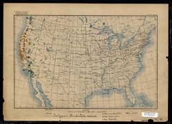
- One of a series of maps created or annotated by Alfred C. Kinsey. Most contain gall wasp data. Several only contain data on other types of flora and fauna. On this map, data points appear in California, Idaho, Nevada, Oregon, Utah, and Washington. Data points also extend into the Mexican state of Baja California (listed on base map in English as "Lower California"). Several data points extend south beyond the printed border of the map to include data from the southernmost portion of the Baja peninsula. Species are listed in Latin (binomial nomenclature) and color coded (see Caption field).
- Caption
- Var. occidentalis, Var. biseriatus, Var. taylori, Var. Beckii. This map is torn in several places on the bottom edge. One tear obscures the end of a handwritten item, likely a name. The portion still visible reads "Milo M".
- Country
- United States
- Filename
- VAE1595-000008
- Subject
- Reptiles
- Entomologists
- Title
- Sceloporus Occidentalis, Baird & Girard
- Producer
- Kinsey, Alfred C. (Alfred Charles), 1894-1956
- Physical Description
- Base map type 1 (USGS. Edition of May 1906, reprinted 1922.) Map scale indicated in both graphic representation and representative fraction.
- Scale: 1:11,875,000
- Print Size: 7.5 x 11.5
- Language
- English
- Latin
- Item Identifiers
- Map D2
- Persistent Identifier
- Holding Location
- Bloomington - Herman B Wells Library
1320 E 10th St.
Bloomington, IN 47405
Contact at libref@iu.edu, (812) 855-0100
- Bloomington - Herman B Wells Library
- Campus
- IU Bloomington
- Date Created
- Circa 1917-1937
Relationships
Relationships
- In Collection:
Items
Show Item Images
| Thumbnail | Title | Date Uploaded | Visibility | Actions |
|---|---|---|---|---|
|
VAE1595-000008.jp2 | 2024-04-01 | Public |
|