
Image
Kentucky-Indiana Prospect quadrangle [1941 reprint] Public Deposited
- Genre
- Topographic maps
- Quadrangle maps
- 15 minute topographic maps
- Location
- Coordinates: W0854500 W0853000 N0383000 N0381500
- Related URL
- Abstract
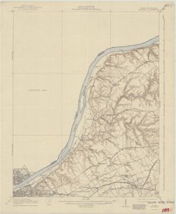
- R.B. Marshall, chief geographer , W.H. Herron, geographer in charge , topography by Chas. E. Cooke and L. Scott Smith , control by J.R. Ellis, C.H. Semper, and Fox Wood. Filing title: Ky.-Ind. Prospect. Edition of Apr. 1912. Polyconic projection. Relief shown by contours and spot heights. Shows portions of Jefferson and Oldham County. Indiana counties marked as "Unsurveyed area." Surveyed in 1905. Surveyed in cooperation with the State of Kentucky. Reprinted in 1920 and 1941. "Map of the Owen quadrangle, scale 1:24,000, contour interval 10 feet, from a later and more detailed survey of the Indiana part of the northeast quarter of this quadrangle, is available." "N3815-W8530/15."
- Call Number
- G4090 s62 .G4 Prospect 1912 rep1941
- Caption
- Imprint: [Washington, D.C.] : U.S. Geological Survey, 1941
- Filename
- VAC3073-M-01389
- Subject
- Geographic Subject: Oldham County (Ky.)
- Geographic Subject: Jefferson County (Ky.)
- Title
- Kentucky-Indiana Prospect quadrangle [1941 reprint]
- Producer
- Smith, L. Scott
- Ellis, J. R. (Topographer)
- Cooke, Chas. E. (Charles E.)
- Kentucky Geological Survey
- Marshall, R. B. (Robert Bradford), 1867-1949
- Herron, W. H. (William Harrison), 1865-
- Geological Survey (U.S.)
- Physical Description
- Scale: 1:62,500
- Dimensions: 45 x 42 cm or smaller
- Item Identifiers
- Title Control Number: a18413939
- Persistent Identifier
- Campus
- IU Bloomington
- Date Created
- 1941
- Provenance
- Part of Geological Survey (U.S.). Indiana 1:62,500.
- Publisher
- Geological Survey (U.S.)
Relationships
Relationships
- In Collection:
Items
Show Item Images
| Thumbnail | Title | Date Uploaded | Visibility | Actions |
|---|---|---|---|---|
|
VAC3073-M-01389.jp2 | 2023-09-28 | Public |
|