
Image
Bridgman's new sectional and township map of Indiana from the latest official and other authentic sources for school, library or office. Public Deposited
- Genre
- Maps
- Location
- Coordinates: W0880700 W0844500 N0414500 N0375200
- Related URL
- Abstract
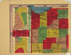
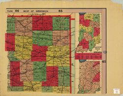
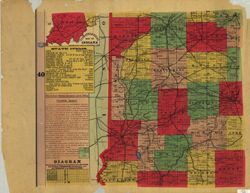
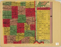
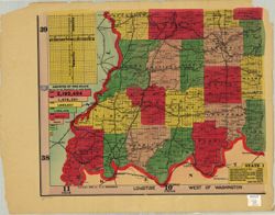
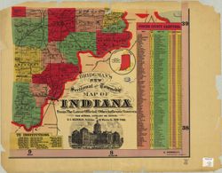
- Shows counties, townships, sections and railroads. Prime meridians: Greenwich and Washington. Includes "Geological map of Indiana" , List of territorial and state governors, 1787-1893 , "State items" , "The United States General Land Office township system" , Population graph, 1920-1890 , "State institutions" , "Comparative areas" map of Indiana and England : map of "Congressional districts of Indiana" , "Rank and populations of largest cities" , "Hypsometric map of Indiana" , "Civil government" chart and "Concise county gazetteer."
- Call Number
- G4090 1894 .B75
- Caption
- Imprint: New York : E. C. Bridgman, [1894]
- Filename
- VAC3073-M-00696
- Subject
- Geographic Subject: Indiana
- Title
- Bridgman's new sectional and township map of Indiana from the latest official and other authentic sources for school, library or office.
- Producer
- Bridgman, E. C.
- Physical Description
- Dimensions: 181 x 137 cm, on sheets 71 x 92 cm
- Scale: 1:264,000
- Item Identifiers
- Title Control Number: CAF4140BB
- Persistent Identifier
- Campus
- IU Bloomington
- Date Created
- 1894
- Publisher
- Bridgman, E. C.
Relationships
Relationships
- In Collection:
Items
Show Item Images
| Thumbnail | Title | Date Uploaded | Visibility | Actions |
|---|---|---|---|---|
|
VAC3073-M-00696.jp2 | 2023-09-25 | Public |
|
|
VAC3073-00376.jp2 | 2023-09-25 | Public |
|
|
VAC3073-00377.jp2 | 2023-09-25 | Public |
|
|
VAC3073-00378.jp2 | 2023-09-25 | Public |
|
|
VAC3073-00379.jp2 | 2023-09-25 | Public |
|
|
VAC3073-00380.jp2 | 2023-09-25 | Public |
|