
Image
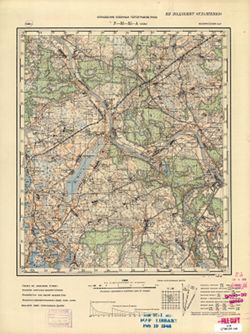
N-35-35-А Улла Public Deposited
- Original Publication Date
1936
- Genre
- Topographic Maps
- Military Maps
- Location
- Coordinates: 55.1667, 29, 55.3333, 29.25
- Related URL
- Abstract
- Modern area represented: Ula, Vitebsk oblast, Belarus
- Call Number
- G7000 s50 .S68 sheet N-35-35-A
- Caption
- Не подлежит оглашению
- City
- Улла (Ulla)
- Copyright Owner
- No Copyright - United States
- Country
- СССР (USSR)
- Filename
- VAC9619-000508
- Subject
- Topical Subject: Soviet Union
- Geographic Subject: Ula
- Topical Subject: Maps
- State/Region
- Белорусская ССР (Byelorussian Soviet Socialist Republic)
- Title
- N-35-35-А Улла
- Physical Description
- Scale: 1:50,000
- Language
- Russian
- Persistent Identifier
- Campus
- IU Bloomington
- Provenance
- M. I. Map Library, Justus Perthes Kartensammlung, GS, RA, G000-30
- Publisher
- Управление военных топографов РККА
Relationships
Relationships
- In Collection:
Items
Show Item Images
| Thumbnail | Title | Date Uploaded | Visibility | Actions |
|---|---|---|---|---|
|
VAC9619-000508.jp2 | 2023-11-29 | Public |
|