
Image
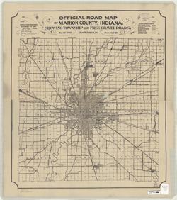
Official road map of Marion County, Indiana showing township and free gravel roads Public Deposited
- Genre
- Road maps
- Location
- Coordinates: W0861941 W0855614 N0395538 N0393755
- Related URL
- Abstract
- "H.C. Bauer Eng. Co." Copy 1 has red annotations.
- Call Number
- G4093.M3 P2 1905 .P3
- Caption
- Imprint: Indianapolis, Ind. : Indianapolis Map & Platting Co., [1905]
- Filename
- VAC3073-M-00652
- Subject
- Geographic Subject: Indianapolis (Ind.)
- Topical Subject: Roads
- Geographic Subject: Marion County (Ind.)
- Title
- Official road map of Marion County, Indiana showing township and free gravel roads
- Producer
- Palmer, Thos. W. (Thomas W.)
- Physical Description
- Scale: 1:64,000
- Dimensions: 63 x 55 cm, on sheet 69 x 61 cm
- Item Identifiers
- Title Control Number: a6082201
- Persistent Identifier
- Campus
- IU Bloomington
- Date Created
- 1905
- Publisher
- Indianapolis Map & Platting Co.
Relationships
Relationships
- In Collection:
Items
Show Item Images
| Thumbnail | Title | Date Uploaded | Visibility | Actions |
|---|---|---|---|---|
|
VAC3073-M-00652.jp2 | 2023-09-25 | Public |
|
|
VAC3073-00160.jp2 | 2023-09-25 | Public |
|