
Image
Indiana St. Meinrad quadrangle [1903 printing] Public Deposited
- Genre
- Quadrangle maps
- 15 minute topographic maps
- Topographic maps
- Location
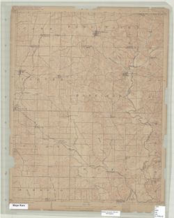
- Coordinates: W0870000 W0864500 N0381500 N0380000
- Related URL
- Abstract
- Jno. H. Renshawe, geographer in charge , control by Geo. T. Hawkins , topography by Chas. W. Goodlove , engraved Jan. 1903 by U.S.G.S. Edition of 1903. Polyconic projection. Relief shown by contours and spot heights. Contour interval 20 feet. Includes diagram of township. Surveyed in 1900. Reprinted 1936. On 1936 reprint: "Polyconic projection." Shows portion of Spencer County, Indiana, and small portions of Dubois and Perry counties in Indiana.
- Call Number
- G4090 s62 .G4 St. Meinrad 1903
- Caption
- Imprint: Washington, D.C. : U.S. Geological Survey, 1903
- Filename
- VAC3073-M-01305
- Subject
- Geographic Subject: Dubois County (Ind.)
- Geographic Subject: Spencer County (Ind.)
- Geographic Subject: Perry County (Ind.)
- Title
- Indiana St. Meinrad quadrangle [1903 printing]
- Producer
- Goodlove, C. W.
- Renshawe, John H.
- Geological Survey (U.S.)
- Hawkins, Geo. T. (George T.)
- Physical Description
- Dimensions: 45 x 42 cm or smaller
- Scale: 1:62,500
- Item Identifiers
- Title Control Number: a18413973
- Persistent Identifier
- Campus
- IU Bloomington
- Date Created
- 1903
- Provenance
- Part of Geological Survey (U.S.). Indiana 1:62,500.
- Publisher
- Geological Survey (U.S.)
Relationships
Relationships
- In Collection:
Items
Show Item Images
| Thumbnail | Title | Date Uploaded | Visibility | Actions |
|---|---|---|---|---|
|
VAC3073-M-01305.jp2 | 2023-09-28 | Public |
|