
Image
Vanderburgh County soil map Public Deposited
- Genre
- Thematic maps
- Location
- Coordinates: W0874202 W0872657 N0381006 N0374932
- Related URL
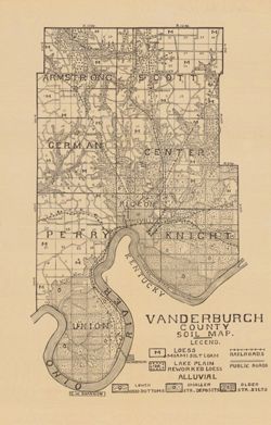
- Abstract
- Shows railroads and public roads. Detached from: A soil survey of Vanderburgh, Gibson, and Pike, and parts of Warrick and Spencer counties / Chas. W. Shannon. In Indiana Department of Geology and Natural Resources thirty-fourth annual report ... 1909. Indianapolis : Wm. B. Burford, 1910. Page 166.
- Call Number
- G4093.V3J3 1909 .S5
- Caption
- Imprint: [Indianapolis] : [Indiana Department of Geology and Natural Resources], [1910]
- Filename
- VAC3073-M-00292
- Subject
- Topical Subject: Soils
- Geographic Subject: Vanderburgh County (Ind.)
- Title
- Vanderburgh County soil map
- Producer
- Shannon, C. W. (Charles William), 1879-1934
- Physical Description
- Dimensions: 37 x 24 cm
- Scale: Approximately 1:126,720
- Item Identifiers
- Alternate ID: 390726IP
- Title Control Number: a16123565
- Persistent Identifier
- Campus
- IU Bloomington
- Date Created
- 1910
- Provenance
- 34th Annual Report (1909) / Indiana. Department of Geology and Natural Resources.
- Publisher
- Indiana. Department of Geology and Natural Resources
Relationships
Relationships
- In Collection:
Items
Show Item Images
| Thumbnail | Title | Date Uploaded | Visibility | Actions |
|---|---|---|---|---|
|
VAC3073-00269.jp2 | 2023-09-25 | Public |
|