
Image
Natural gas map of Indiana Public Deposited
- Genre
- Geological maps
- Location
- Coordinates: W0880700 W0844500 N0414500 N0375200
- Related URL
- Abstract
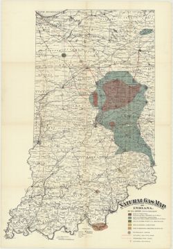
- Shows natural and man-made gas and petroleum features as well as county seats, townships, towns, post offices, railroads, and creeks. Detached from: Natural gas : report of state supervisor / [E. T. J. Jordan]. In Indiana Department of Geology and Natural History eighteenth annual report ... 1893. Indianapolis : Wm. B. Burford, contractor for state printing and binding, 1984.
- Call Number
- G4091.H8 1893 .G6
- Caption
- b[Indiana. Department of Geology and Natural Resources], [1894]
- Imprint: Indianapolis, Ind. : Wm. B. Burford, Lith., [1894]
- Imprint: [Indianapolis] :
- Filename
- VAC3073-M-01253
- Subject
- Topical Subject: IGS Annual Reports
- Topical Subject: Petroleum
- Topical Subject: Natural gas pipelines
- Topical Subject: Gas fields
- Topical Subject: Gas wells
- Geographic Subject: Indiana
- Title
- Natural gas map of Indiana
- Producer
- Gorby, S. S. (Sylvester Scott)
- Physical Description
- Dimensions: 89 x 62 cm
- Scale: Approximately 1:570,240. 9 miles to the inch
- Item Identifiers
- Alternate ID: 390726IP
- Title Control Number: a18416363
- Persistent Identifier
- Campus
- IU Bloomington
- Date Created
- 1894
- Provenance
- 18th Annual Report (1893) / Indiana. Department of Geology and Natural Resources.
- Publisher
- Indiana. Department of Geology and Natural Resources
Relationships
Relationships
- In Collection:
Items
Show Item Images
| Thumbnail | Title | Date Uploaded | Visibility | Actions |
|---|---|---|---|---|
|
VAC3073-M-01253.jp2 | 2023-09-28 | Public |
|