
Image
Map of Veedersburg City and vicinity Public Deposited
- Genre
- Geological maps
- Location
- Coordinates: W0871723 W0871347 N0401012 N0400505
- Related URL
- Abstract
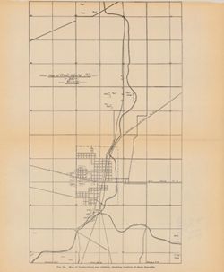
- Caption title: Map of Veedersburg and vicinity, showing the location of shale deposits. "Fig. 2a." Detached from: The clays and clay industries of Indiana / W. S. Blatchley. In Indiana Department of Geology and Natural Resources twenty-ninth annual report ... 1904. Indianapolis : Wm. B. Burford, 1905. Page 82.
- Call Number
- G4094.V3H5 1904 .M37
- Caption
- Imprint: [Indianapolis] : [Wm. B. Burford], [1905]
- Imprint: [Indianapolis] : [Indiana Department of Geology and Natural Resources], [1905]
- Filename
- VAC3073-M-00371
- Subject
- Geographic Subject: Veedersburg City Region (Ind.)
- Topical Subject: Shale
- Geographic Subject: Fountain County (Ind.)
- Topical Subject: IGS Annual Reports
- Title
- Map of Veedersburg City and vicinity
- Physical Description
- Dimensions: on sheet 27 x 23 cm
- Scale: Approximately 1:34,250
- Item Identifiers
- Alternate ID: 390726IP
- Title Control Number: a18282209
- Persistent Identifier
- Campus
- IU Bloomington
- Date Created
- 1905
- Provenance
- 29th Annual Report (1904) / Indiana. Department of Geology and Natural Resources.
- Publisher
- Indiana. Department of Geology and Natural Resources
Relationships
Relationships
- In Collection:
Items
Show Item Images
| Thumbnail | Title | Date Uploaded | Visibility | Actions |
|---|---|---|---|---|
|
VAC3073-00270.jp2 | 2023-09-25 | Public |
|