
Image
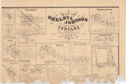
Map of Shelby & Johnson Counties, Indiana : from actual surveys Public Deposited
- Genre
- Cadastral maps
- Location
- Coordinates: W0861020 W0853744 N0394156 N0392050
- Related URL
- Abstract
- Cadastral maps showing landowners and businesses. Includes tables of distances for Shelby Co.and Johnson Co.
- Call Number
- G4093.S4 G46 1866 .W3
- Caption
- Imprint: Philadelphia : C.O. Titus, 1867, [1866]
- Filename
- VAC3073-M-00977
- Subject
- Topical Subject: Cities and towns
- Topical Subject: Landowners
- Geographic Subject: Shelby County (Ind.)
- Topical Subject: Real property
- Geographic Subject: Johnson County (Ind.)
- Title
- Map of Shelby & Johnson Counties, Indiana : from actual surveys
- Producer
- Warner, A.
- Physical Description
- Dimensions: 51 x 77 cm
- Scale: Scales differ.
- Item Identifiers
- Title Control Number: CAG7848BB
- Persistent Identifier
- Campus
- IU Bloomington
- Date Created
- 1866
- Publisher
- Titus, C. O.
Relationships
Relationships
- In Collection:
Items
Show Item Images
| Thumbnail | Title | Date Uploaded | Visibility | Actions |
|---|---|---|---|---|
|
VAC3073-M-00977.jp2 | 2023-09-27 | Public |
|
|
VAC3073-00401.jp2 | 2023-09-27 | Public |
|