
Image
Bloomington Indiana Public Deposited
- Genre
- Thematic maps
- Location
- Coordinates: W0863323 W0862823 N0391046 N0390854
- Related URL
- Abstract
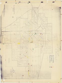
- Blue line print. Appears to show election precincts within the Bloomington corporation limits. B-GEOMAP: Hand annotated in the spring of 1961 to show locations where persons of Greek ethnology live, work, and own real estate with colored dots and with Covenenter Drive and Parkridge areas added in blue pencil.
- Call Number
- G4094.B5 F7 1955 .C175
- Caption
- Imprint: Bloomington, Ind. : C.-M. Engineering, 1955.
- Filename
- VAC3073-M-00795
- Subject
- Topical Subject: Election districts
- Geographic Subject: Bloomington (Ind.)
- Title
- Bloomington Indiana
- Producer
- C.-M. Engineering
- Physical Description
- Scale: 1:3,500
- Dimensions: 103 x 132 cm
- Item Identifiers
- Title Control Number: a5300319
- Persistent Identifier
- Campus
- IU Bloomington
- Date Created
- 1955
- Publisher
- C.-M. Engineering
Relationships
Relationships
- In Collection:
Items
Show Item Images
| Thumbnail | Title | Date Uploaded | Visibility | Actions |
|---|---|---|---|---|
|
VAC3073-M-00795.jp2 | 2023-10-17 | Public |
|