
Image
Clay County soil map Public Deposited
- Genre
- Thematic maps
- Related URL
- Abstract
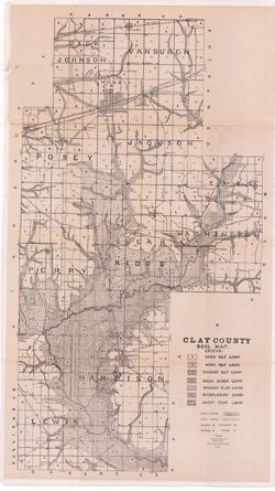
- Detached from: Soil survey of Clay, Knox, Sullivan and Vigo counties / by Charles W. Shannon. In Thirty-sixth annual report of Department of Geology and Natural Resources, Indiana, 1911. Indianapolis: Wm. B. Burford, 1912. Page 170.
- Call Number
- QE109 .A2 1911 map p170
- Caption
- Imprint: [Indianapolis] : [Department of Geology and Natural Resources, Indiana], [1912] [Indianapolis] : [Wm. B. Burford], [1912]
- Filename
- VAC3073-M-01093
- Subject
- Topical Subject: IGS Annual Reports
- Geographic Subject: Clay County (Ind.)
- Topical Subject: Soils
- Title
- Clay County soil map
- Producer
- Shannon, M. E.
- Shannon, C. W. (Charles William), 1879-1934
- Physical Description
- Scale: Approximately 1:63,360
- Dimensions: 80 x 45 cm
- Item Identifiers
- Title Control Number: 390726IP
- Persistent Identifier
- Campus
- IU Bloomington
- Date Created
- 1912
- Provenance
- 36th Annual Report (1911) / Indiana. Department of Geology and Natural Resources.
- Publisher
- Indiana. Department of Geology and Natural Resources
Relationships
Relationships
- In Collection:
Items
Show Item Images
| Thumbnail | Title | Date Uploaded | Visibility | Actions |
|---|---|---|---|---|
|
VAC3073-00054.jp2 | 2023-09-27 | Public |
|