
Image
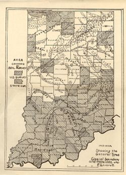
Indiana showing the general types, glacial boundary and moraines after F. Leverett Public Deposited
- Genre
- Thematic maps
- Index maps
- Location
- Coordinates: W0880500 W0844700 N0414500 N0374600
- Related URL
- Abstract
- Shows counties covered by a U.S. soil survey or a state soil survey. Detached from: Glaciation and soils / Edward Barrett. In Thirty-sixth annual report of Department of Geology and Natural Resources, Indiana, 1911. Indianapolis: Wm. B. Burford, 1912. Page 11.
- Call Number
- G4091.C38 1911 .I5
- Caption
- Imprint: [Indianapolis] : [Department of Geology and Natural Resources, Indiana], [1912]
- Filename
- VAC3073-M-01144
- Subject
- Topical Subject: Soil surveys
- Geographic Subject: Indiana
- Topical Subject: IGS Annual Reports
- Topical Subject: Moraines
- Topical Subject: Glacial epoch
- Title
- Indiana showing the general types, glacial boundary and moraines after F. Leverett
- Physical Description
- Scale: Approximately 1:1,750,000
- Dimensions: 24 x 18 cm
- Item Identifiers
- Alternate ID: 390726IP
- Title Control Number: a18307837
- Persistent Identifier
- Campus
- IU Bloomington
- Date Created
- 1912
- Provenance
- 36th Annual Report (1911) / Indiana. Department of Geology and Natural Resources.
- Publisher
- Indiana. Department of Geology and Natural Resources
Relationships
Relationships
- In Collection:
Items
Show Item Images
| Thumbnail | Title | Date Uploaded | Visibility | Actions |
|---|---|---|---|---|
|
VAC3073-00296.jp2 | 2023-09-27 | Public |
|