
Image
Map of Montgomery County, Indiana Public Deposited
- Genre
- Geological maps
- Location
- Coordinates: W0870530 W0864134 N0401301 N0395151
- Related URL
- Abstract
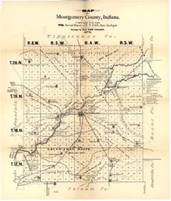
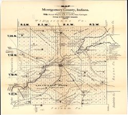
- Compiled for the 7th annual report of E.T. Cox, State Geologist , geology by Prof. John Collett, 1875. Relief shown by hachures. Shows cities and towns, railroads, mills, fossil beds, springs, swamps, limestone, sandstone, conglomerate, quarries, and coal. Detached from: Seventh annual report of the Geological Survey of Indiana, made in the year 1875. Indianapolis : Sentinel Company, 1876.
- Call Number
- G4093.M8C5 1875 .C6
- Caption
- Imprint: [Indianapolis] : [Geological Survey of Indiana], [1876]
- Imprint: [Indianapolis] : [Sentinel Company, printers], [1876]
- Filename
- VAC3073-M-01175
- Subject
- Topical Subject: Mines and mineral resources
- Geographic Subject: Montgomery County (Ind.)
- Topical Subject: Coal mines and mining
- Topical Subject: IGS Annual Reports
- Topical Subject: Geology
- Title
- Map of Montgomery County, Indiana
- Producer
- Collett, John, 1828-1899
- Cox, E. T. (Edward Travers), 1821-1907
- Physical Description
- Scale: Approximately 1:120,000
- Dimensions: on sheet 48 x 40 cm
- Item Identifiers
- Alternate ID: 390723IP
- Title Control Number: a18349279
- Persistent Identifier
- Campus
- IU Bloomington
- Date Created
- 1876
- Provenance
- 7th Annual Report (1875) / Indiana. Geological Survey.
- Publisher
- Indiana. Geological Survey
Relationships
Relationships
- In Collection:
Items
Show Item Images
| Thumbnail | Title | Date Uploaded | Visibility | Actions |
|---|---|---|---|---|
|
VAC3073-M-01175.jp2 | 2023-09-27 | Public |
|
|
VAC3073-00944.jp2 | 2023-09-27 | Public |
|