
Image
Monroe County soil map Public Deposited
- Genre
- Thematic maps
- Related URL
- Abstract
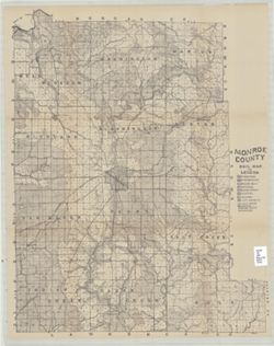
- Shows roads, earth and improved, railroads, school houses, and churches. Detached from: Soil survey of Monroe, Brown, Lawrence, Martin, Orange, Washington, and Jackson counties / C.W. Shannon and L.C. Snider. In Indiana Dept. of Geology and Natural Resources thirty-second annual report, 1907. Indianapolis: Wm. B. Burford, 1908.
- Call Number
- QE109 .A2 1907 Map p.123 Monroe County
- Caption
- Imprint: [Indianapolis : 1908].
- Filename
- VAC3073-M-01532
- Subject
- Geographic Subject: Monroe County (Ind.)
- Topical Subject: IGS Annual Reports
- Topical Subject: Mines and mineral resources
- Topical Subject: Geology
- Title
- Monroe County soil map
- Producer
- Shannon, C. W. (Charles William), 1879-1934
- Physical Description
- Dimensions: on sheet 66 x 52 cm
- Scale: Approximately 1:63,360
- Persistent Identifier
- Campus
- IU Bloomington
- Date Created
- 1908
- Publisher
- Indiana. Department of Geology and Natural Resources
Relationships
Relationships
- In Collection:
Items
Show Item Images
| Thumbnail | Title | Date Uploaded | Visibility | Actions |
|---|---|---|---|---|
|
VAC3073-M-01532.jp2 | 2023-09-28 | Public |
|