
Image
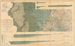
Geological map of the coal region of Indiana. Sheet C, Sullivan and Greene Counties, to accompany the Report on the coal of Indiana Public Deposited
- Genre
- Geological cross-sections
- Geological maps
- Location
- Coordinates: W0873900 W0864200 N0391530 N0385400
- Related URL
- Abstract
- Relief shown by spot heights. Includes map showing the location of coal locations, coal features, and railroads, as well as geological cross sections for several locations in Greene and Sullivan Counties. "Map based upon: Congressional land survey. Field work of this survey. County atlases of Greene and Sullivan Counties." Geology by G.H. Ashley and C.E. Siebenthal. Detached from: The coal deposits of Indiana / George Hall Ashley. In Indiana Department of Geology and Natural Resources twenty-third annual report, 1898. Indianapolis : Wm. B. Burford, 1899. Page 766.
- Call Number
- G4093.S8H9 1898 .A84
- Caption
- Imprint: Indianapolis, Ind. : Wm. B. Burford, [1899]
- Filename
- VAC3073-M-00945
- Subject
- Geographic Subject: Sullivan County (Ind.)
- Geographic Subject: Greene County (Ind.)
- Topical Subject: Geology
- Topical Subject: Coal
- Topical Subject: IGS Annual Reports
- Title
- Geological map of the coal region of Indiana. Sheet C, Sullivan and Greene Counties, to accompany the Report on the coal of Indiana
- Producer
- Ashley, Geo. H. (George Hall), 1866-1951
- Siebenthal, C. E. (Claude Ellsworth), 1869-1930
- Physical Description
- Scale: Approximately 1:126,720. 2 miles = 1 inch. Vertical scale approximately 1:4,800. 1 inch = 400 feet
- Dimensions: 48 x 78 cm
- Item Identifiers
- Alternate ID: 390726IP
- Title Control Number: a18265344
- Persistent Identifier
- Campus
- IU Bloomington
- Date Created
- 1899
- Provenance
- 23rd Annual Report (1898) / Indiana. Department of Geology and Natural Resources.
- Publisher
- Indiana. Department of Geology and Natural Resources
Relationships
Relationships
- In Collection:
Items
Show Item Images
| Thumbnail | Title | Date Uploaded | Visibility | Actions |
|---|---|---|---|---|
|
VAC3073-00065.jp2 | 2023-09-27 | Public |
|