
Image
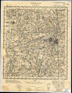
N-36-49 Орша Public Deposited
- Original Publication Date
1936
- Genre
- Topographic Maps
- Military Maps
- Location
- Coordinates: 54.333, 30, 54.667, 30.5
- Related URL
- Abstract
- Modern area represented: Orsha, Vitebsk oblast, Belarus
- Call Number
- G7000 s100 .S7 sheet N-36-49
- Caption
- Не подлежит оглашению
- City
- Орша (Orsha)
- Copyright Owner
- No Copyright - United States
- Country
- СССР (USSR)
- Filename
- VAC9619-004189
- Subject
- Topical Subject: Maps
- Topical Subject: Soviet Union
- Geographic Subject: Orsha
- State/Region
- Могилевская область (Mogilev oblast)
- Витебская область (Vitebsk oblast)
- Белорусская ССР (Byelorussian Soviet Socialist Republic)
- Title
- N-36-49 Орша
- Physical Description
- Scale: 1:100,000
- Language
- Russian
- Persistent Identifier
- Campus
- IU Bloomington
- Date Created
- 1937
- Provenance
- DMA Topographic Center, Army Map Service Library, OMAHA
- Publisher
- Генеральный штаб РККА
Relationships
Relationships
- In Collection:
Items
Show Item Images
| Thumbnail | Title | Date Uploaded | Visibility | Actions |
|---|---|---|---|---|
|
VAC9619-004189.jp2 | 2024-02-14 | Public |
|
|
VAC9619-U-004318.jp2 | 2024-02-14 | Public |
|