
Image
Map of the Wabash-Erie Region Public Deposited
- Genre
- Geological maps
- Location
- Coordinates: W0860630 W0832600 N0415400 N0401530
- Related URL
- Abstract
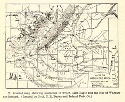
- Caption title: Glacial map showing moraines in which Lake Eagle and the city of Warsaw are located. Relief shown by profile. Includes geological profile of region. Shows moraines and beach lines in Ohio and Indiana. "Map 2." "Loaned by Prof. C. R. Dryer and Inland Pub. Co."--Caption. Detached from: A physiographic and ecological study of the Lake Eagle (Winona Lake) Region, Indiana / by W. M. Mills. In Indiana Department of Geology and Natural Resources twenty-eighth annual report, 1903. Indianapolis : Wm. B. Burford, 1904.
- Call Number
- QE109 .A2 1903
- Caption
- Imprint: [Indianapolis] : [Wm. B. Burford], [1904]
- Imprint: [Indianapolis] : [Indiana Department of Geology and Natural Resources], [1904]
- Filename
- VAC3073-M-01578
- Subject
- Geographic Subject: Indiana
- Topical Subject: Moraines
- Geographic Subject: Ohio
- Topical Subject: IGS Annual Reports
- Title
- Map of the Wabash-Erie Region
- Producer
- Dryer, Charles Redway, 1850-1927
- Physical Description
- Dimensions: 8 x 11 cm
- Scale: Approximately 1:2,476,000. Vertical scale indeterminable
- Item Identifiers
- Alternate ID: 390726IP
- Title Control Number: a18418361
- Persistent Identifier
- Campus
- IU Bloomington
- Date Created
- 1904
- Provenance
- 28th Annual Report (1903) / Indiana. Department of Geology and Natural Resources.
- Publisher
- Indiana. Department of Geology and Natural Resources
Relationships
Relationships
- In Collection:
Items
Show Item Images
| Thumbnail | Title | Date Uploaded | Visibility | Actions |
|---|---|---|---|---|
|
VAC3073-M-01578.jp2 | 2023-09-28 | Public |
|