
Image
Ohio and Indiana Public Deposited
- Genre
- Maps
- Location
- Coordinates: W0880558 W0842342 N0414540 N0374618
- Related URL
- Abstract
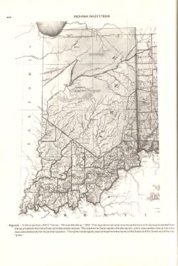
- Title from caption. Statement of responsibility from caption. Shows areas of Indiana held by the Potawatomi and Kickapoo tribes. "Figure 6.--Indiana portion of H.S. Tanner's 'Ohio and Indiana,' 1922"--Caption. Appears as Figure 6 in Indiana Gazetteer produced by the U.S.G.S. Professional Paper 1200-I. "The National Gazetteer of the United States of America--Indiana 1988. Prepared by the U.S. Geological Survey in cooperation with the U.S. Board on Geographic names.
- Call Number
- QE75 .A4 No. 1200-IN
- Caption
- Imprint: [Reston, Va.] : [U.S. Geological Survey], [1988]
- Filename
- VAC3073-M-00296
- Subject
- Topical Subject: Potawatomi Tribe
- Geographic Subject: Indiana
- Topical Subject: Kickapoo Tribe of Indians
- Title
- Ohio and Indiana
- Producer
- Tanner, Henry Schenck, 1786-1858
- Physical Description
- Scale: Indeterminable
- Dimensions: 29 cm or smaller
- Item Identifiers
- Title Control Number: a18454603
- Alternate ID: 358171IP
- Persistent Identifier
- Campus
- IU Bloomington
- Date Created
- 1988
- Provenance
- The National gazetteer of the United States of America--Indiana, 1988 / U.S. Geological Survey.
- Publisher
- Geological Survey (U.S.)
Relationships
Relationships
- In Collection:
Items
Show Item Images
| Thumbnail | Title | Date Uploaded | Visibility | Actions |
|---|---|---|---|---|
|
VAC3073-M-00296.jp2 | 2023-09-25 | Public |
|