
Image
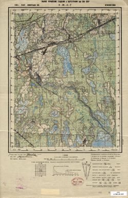
О-36-3-Г Поляна Public Deposited
- Original Publication Date
1939
- Genre
- Topographic Maps
- Military Maps
- Location
- Coordinates: 59.6667, 31.25, 59.8333, 31.5
- Related URL
- Abstract
- Modern area represented: Polyana, Russia
- Call Number
- G7000 s50 .S68 sheet O-36-3-D
- City
- Поляна (Polyana)
- Copyright Owner
- No Copyright - United States
- Country
- СССР (USSR)
- Filename
- VAC9619-000007
- Subject
- Geographic Subject: Polyana
- Topical Subject: Soviet Union
- State/Region
- Ленинградская область (Leningrad oblast)
- Мгинский район (Mginsky district)
- РСФСР (RSFSR)
- Title
- О-36-3-Г Поляна
- Physical Description
- Scale: 1:50,000
- Language
- Russian
- Persistent Identifier
- Campus
- IU Bloomington
- Date Created
- 1939
- Provenance
- Army Map Service Library, OMAHA, Library of Congress Geography & Map Division
- Publisher
- Главное управление геодезии и картографии при СНК СССР
Relationships
Relationships
- In Collection:
Items
Show Item Images
| Thumbnail | Title | Date Uploaded | Visibility | Actions |
|---|---|---|---|---|
|
VAC9619-000007.jp2 | 2023-11-03 | Public |
|
|
VAC9619-U-002740.jp2 | 2023-11-03 | Public |
|