
Image
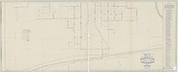
Water Works distribution system map of the southern part of Danville, Hendricks County, Indiana Public Deposited
- Genre
- Thematic maps
- Location
- Coordinates: W0863309 W0862726 N0394705 N0394353
- Related URL
- Abstract
- Blue line print. Includes index of "References and descriptions of the location of gate valves."
- Call Number
- G4094 .D3 N44 1947 .S53
- Caption
- Imprint: [Danville, Ind.?] : [Stanley M. Shartle?], [1947]
- Filename
- VAC3073-M-00611
- Subject
- Topical Subject: Water utilities
- Geographic Subject: Danville (Ind.)
- Title
- Water Works distribution system map of the southern part of Danville, Hendricks County, Indiana
- Producer
- Shartle, Stanley Musgrave
- Physical Description
- Scale: 1:1,200
- Dimensions: 87 x 198 cm
- Item Identifiers
- Title Control Number: a5359312
- Persistent Identifier
- Campus
- IU Bloomington
- Date Created
- 1947
- Publisher
- Stanley M. Shartle?]
Relationships
Relationships
- In Collection:
Items
Show Item Images
| Thumbnail | Title | Date Uploaded | Visibility | Actions |
|---|---|---|---|---|
|
VAC3073-M-00611.jp2 | 2023-10-18 | Public |
|