
Image
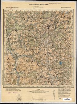
N-35-88 Новогрудок Public Deposited
- Original Publication Date
1895
- Genre
- Topographic Maps
- Military Maps
- Location
- Coordinates: 53.333, 25.5, 53.667, 26
- Related URL
- Abstract
- Modern area represented: Navahrudak, Hrodno oblast, Belarus
- Call Number
- G7000 s100 .S7 sheet N-35-88
- City
- Новогрудок (Navahrudak)
- Copyright Owner
- No Copyright - United States
- Country
- СССР (USSR)
- Filename
- VAC9619-004088
- Subject
- Geographic Subject: Navahrudak
- Topical Subject: Maps
- Topical Subject: Soviet Union
- State/Region
- Белорусская ССР (Byelorussian Soviet Socialist Republic)
- Барановичская область (Baranavichy oblast)
- Title
- N-35-88 Новогрудок
- Physical Description
- Scale: 1:100,000
- Language
- Russian
- Persistent Identifier
- Campus
- IU Bloomington
- Date Created
- 1940
- Provenance
- DMA Topographic Center, Army Map Service Library, OMAHA, Geographic Names Branch
- Publisher
- Генеральный штаб Красной Армии
Relationships
Relationships
- In Collection:
Items
Show Item Images
| Thumbnail | Title | Date Uploaded | Visibility | Actions |
|---|---|---|---|---|
|
VAC9619-004088.jp2 | 2024-02-12 | Public |
|
|
VAC9619-U-004217.jp2 | 2024-02-12 | Public |
|