
Image
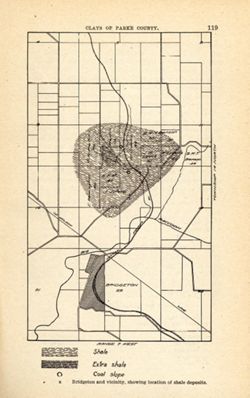
Bridgeton and vicinity, showing location of shale deposits Public Deposited
- Genre
- Geological maps
- Location
- Coordinates: W0871115 W0870900 N0394130 N0393800
- Related URL
- Abstract
- Shows location of shale, extra shale, and coal slope. "Clays of Parke County." Detached from: The clays and clay industries of Indiana / W. S. Blatchley. In Indiana Department of Geology and Natural Resources twenty-ninth annual report ... 1904. Indianapolis : Wm. B. Burford, 1905. Page 119.
- Call Number
- G4093.P2H5 1904 .B75
- Caption
- Imprint: [Indianapolis] : [Indiana Department of Geology and Natural Resources], [1905]
- Imprint: [Indianapolis] : [Wm. B. Burford], [1905]
- Filename
- VAC3073-M-01585
- Subject
- Geographic Subject: Bridgeton Region (Ind.)
- Topical Subject: Mines and mineral resources
- Geographic Subject: Parke County (Ind.)
- Topical Subject: IGS Annual Reports
- Topical Subject: Shale
- Title
- Bridgeton and vicinity, showing location of shale deposits
- Physical Description
- Scale: Scale not given.
- Dimensions: on sheet 22 x 14 cm
- Item Identifiers
- Alternate ID: 390726IP
- Title Control Number: a18279221
- Persistent Identifier
- Campus
- IU Bloomington
- Date Created
- 1905
- Provenance
- 29th Annual Report (1904) / Indiana. Department of Geology and Natural Resources.
- Publisher
- Indiana. Department of Geology and Natural Resources
Relationships
Relationships
- In Collection:
Items
Show Item Images
| Thumbnail | Title | Date Uploaded | Visibility | Actions |
|---|---|---|---|---|
|
VAC3073-M-01585.jp2 | 2023-09-28 | Public |
|