
Image
Fire loss--state of Indiana Public Deposited
- Genre
- Thematic maps
- Fire insurance maps
- Location
- Coordinates: W0880500 W0844700 N0414500 N0374600
- Related URL
- Abstract
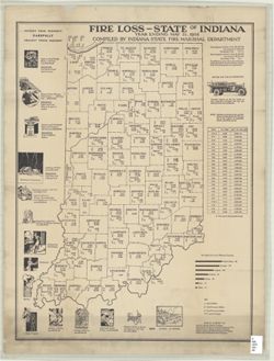
- Provides state-level and county-level figures for fire losses, urban and rural, in dollars and per capita. Also provides statistical table for rural fire losses (1913-1936) and information about causes of fires. "Township trustees are the Fire Chiefs of their respective townships and may and should provide this protection." "Maps by courtesy of Farmer's Mutual Liability Company, Grain Dealer's National Mutual Fire Insurance Co., Indiana Farmer's Mutual Insurance Comany, Indiana Lumberman's Mutual Insurance Company, Indiana Union Mutual Insurance Company."
- Call Number
- G4091.G475 1937 .I53
- Caption
- Imprint: [Indianapolis] : Indiana State Fire Marshal Department, [1937?]
- Filename
- VAC3073-M-00660
- Subject
- Topical Subject: Fire risk assessment
- Geographic Subject: Indiana
- Topical Subject: Fire prevention
- Title
- Fire loss--state of Indiana
- Producer
- Indiana. State Fire Marshal Department
- Physical Description
- Dimensions: 67 x 50 cm
- Scale: 1:1,700,000
- Item Identifiers
- Title Control Number: a9847429
- Persistent Identifier
- Campus
- IU Bloomington
- Date Created
- 1937
- Publisher
- Indiana. State Fire Marshal Department
Relationships
Relationships
- In Collection:
Items
Show Item Images
| Thumbnail | Title | Date Uploaded | Visibility | Actions |
|---|---|---|---|---|
|
VAC3073-M-00660.jp2 | 2023-09-25 | Public |
|